How do Biosystems Engineers Analyze the World?
Geospatial Technologies in Biosystems
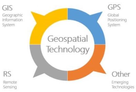
This course dives into subject matter regarding the technology behind Geographic Information Systems (GIS), Global Positioning Systems (GPS) and remote sensing. Through the exploration of GIS, GPS, and remote sensing, skills in the application of GPS/GIS in the public and private sector are acquired.

Global Positioning System
Signals involved are used to calculate: position, velocity & time.

Geographic Information Systems
Making and storing data: combining maps and data for real-world applications.

Remote Sensing
Collecting data via a device that is not in contact with the subject under analysis.

Data Acquisition
Using satellites, aerial photos, infrared radiation data, and multi-spectral scanners, new information about the world is available for study.
Click the icon above to see Rosia’s final course project in Geospatial Technologies.
Want to see some of the work that Rosia has been doing in ArcMap? Click the link below!
Attached are two assignments that Rosia completed in BSEN 5220. The first link will connect to Rosia’s eighth laboratory assignment. Click on the second link to see Rosia’s sixth laboratory assignment.